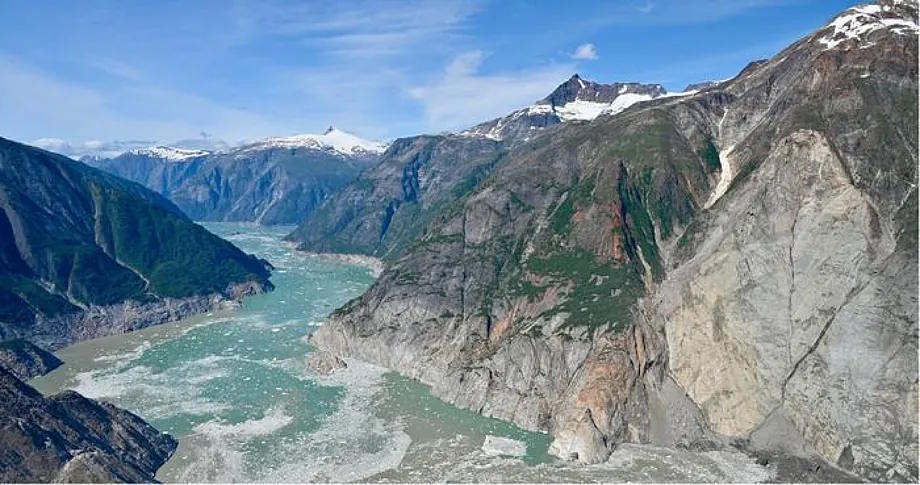
Tsunamis are not only caused by underwater earthquakes. Landslides that result in large land masses impacting the sea can generate gigantic waves - known as megatsunamis - like the ones that formed on August 10th in a fjord in Alaska named Tracy Arm. Despite being a relatively remote location, the beauty of this area has turned it into a tourist destination, with around twenty cruises passing through the fjord during the summer months, some of them carrying thousands of passengers.
A team of scientists has analysed this natural phenomenon that could have caused a catastrophe but went relatively unnoticed as, fortunately, no casualties were reported. The tsunami was triggered at 5:26 in the morning when no vessels were passing through. According to the team led by Dan Shugar from the University of Calgary, this is the second highest megatsunami ever recorded, with the wave reaching 481 meters up the wall of Tracy Arm fjord and generating seismic signals equivalent to a magnitude 5.4 earthquake, detectable in many parts of the world.
The largest documented megatsunami to date occurred in 1958, also in Alaska, reaching a height of 524 meters. For comparison, the highest waves generated by the 2011 tsunami in Tohoku (Japan) were 40 meters.
"We have reconstructed the event from multiple perspectives, including accounts from eyewitnesses such as boat passengers and kayakers," explained Dan Shugar in a press release. For example, a group of kayakers reported waking up around 5:45 when they saw water passing by their tent, carrying away one of their kayaks and much of their equipment. Another witness described a two-meter wave advancing on the beach, while several people on a cruise ship anchored near the fjord's mouth saw currents and white foam, but no evident wave. The scientists also analysed seismic and satellite data recorded before and after the megatsunami occurred.
This is the reconstruction presented in the journal Science: Early on August 10, 2025, a huge wedge-shaped rock block collapsed at the top of the South Sawyer, a glacier that flows into Tracy Arm fjord. This collapse released tens of millions of cubic meters of material that hit the glacier front, displacing ice and water masses that generated a powerful tsunami.
Although there were no visible signs on the slope indicating an imminent large-scale collapse, subtle seismic signals were recorded in the days leading up to it, especially a few hours before the collapse. "Normally, warning signs appear in the weeks, months, or years before these huge rock avalanches when the slope slowly moves downhill, sinks, and then catastrophically gives way in a rock avalanche. But in this case, it didn't happen. Instead of those signs, there was subtle seismic noise, so subtle that it wouldn't have attracted attention. "This was truly a surprise," admits Dan Shugar.
Photograph of Sawyer Island before the tsunami (in 2022), with trees and shrubs that were uprooted by the gigantic 2025 wave. The South Sawyer glacier is visible in the background.Christine Smith
The powerful tsunami stripped vegetation from the steep walls of Tracy Arm fjord, leaving a clearly visible line marking the maximum water level reached. According to their measurements, in one area, it reached 481 meters above sea level.
Although the wave height decreased as it progressed, the destructive effects of the tsunami were felt tens of kilometers away. In addition to the initial large wave, it triggered other water movements within the fjord in the following days, as indicated by data collected by land seismographs and satellites.
Scientists believe that climate change contributed to the triggering of this megatsunami. As stated in their study, the long-term retreat and thinning of the glacier due to regional warming eliminated the structural support of the slope and weakened it.
Therefore, this event has raised concerns about the dangers of navigation in these glacier areas, as large waves could be generated more frequently due to rising temperatures. However, it has also provided valuable lessons to try to prevent these risks associated with melting ice and mitigate some of the impacts.
Thus, scientists believe that the seismic activity prior to the landslide can be useful for developing tools to predict megatsunamis in remote regions in advance like this one, especially vulnerable to the effects of climate change. These precursor signals, they point out, could be detected through direct measurements or remote sensing.
"Until now, we had no way of directly observing these waves, but our study has shown that using data from the new Surface Water Ocean Topography satellite can reveal the complete surface structure of the sea in these events, even if no one witnesses them directly."
As highlighted by Thomas Monahan from the Department of Engineering Sciences at the University of Oxford, satellite observations of ocean dynamics in remote areas are becoming essential as risks in the Arctic intensify.
The authors also hope that their study will help prevent future disasters: "We hope that coastal municipalities, the cruise industry, and other involved parties take these threats seriously," says Shugar, warning that similar events could lead to disasters in the future. At least six cruise companies have adjusted their itineraries in Alaska this year due to the remaining risks in Tracy Arm fjord, as noted by the authors in a press release.
The U.S. Geological Survey has warned on its website that steep mountainous areas prone to landslides are "intrinsically unstable and will continue to change for years after an initial slide."