It was in 1792 when the Malaspina Expedition, named after Commander Alessandro Malaspina, an Italian sailor in the service of the Spanish crown, first mapped the location and size of a sandbank near the Philippine islands. Eight years later, the Spanish government in Manila sent the frigate Santa Lucía, under the command of Granada-born Captain Francisco Riquelme, to that location.
The Philippine archipelago passed from Spanish rule to the United States as a result of the Spanish-American War of 1898, which concluded with the signing of the Treaty of Paris. Two years later, with the Washington Treaty, it was agreed that territories administered by Spain would be ceded to the US, including the aforementioned sandbank to be exploited for fishing and salvage activities. That place was named Scarborough Shoal in honor of a British cargo ship, the HMS Scarborough, which had run aground there in 1784.
After gaining independence in 1946, the Philippines assumed administration of the sandbank, renaming it Bajo de Masinloc and using it as a shooting range during joint maneuvers with the Filipino and American forces, who had established a secure perimeter in a privileged fishing area. However, when the US withdrew its extensive network of military bases from the archipelago in 1991, China began to claim the sandbank with deeds and maps from the 13th century indicating that the area was part of its territory.
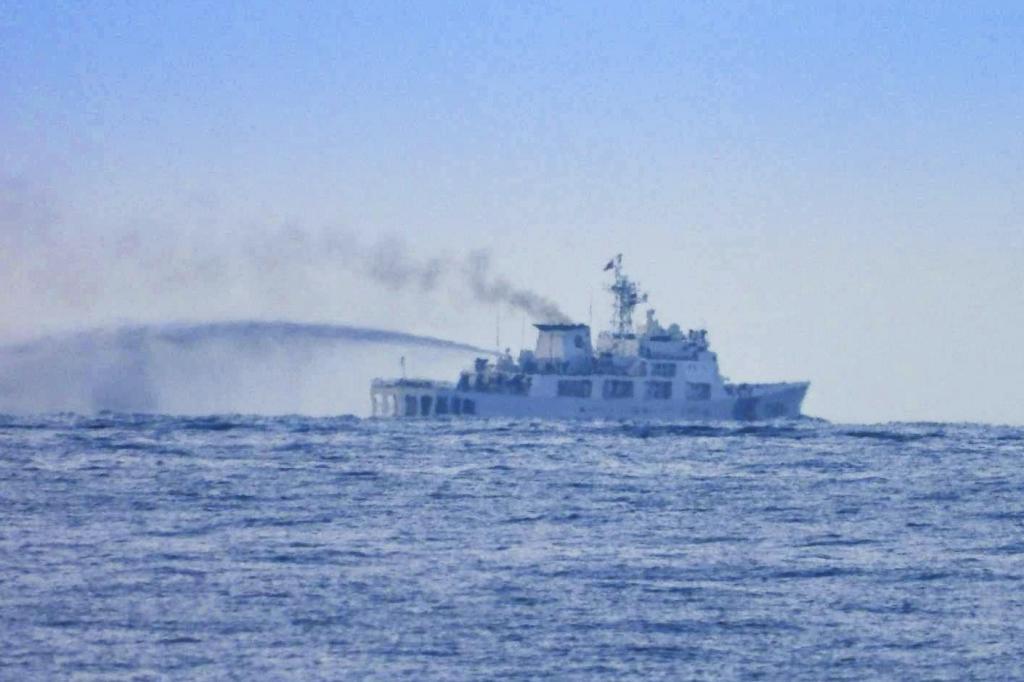
The Scarborough Shoal is now at the center of a dispute between Manila and Beijing that has reignited in recent days after a Chinese Navy ship collided with another vessel from its own coast guard while pursuing a Filipino ship.
This incident occurred on August 11. That same week, the Chinese military announced that its fleet and aircraft had "monitored and expelled" the US destroyer USS Higgins as it sailed near the sandbank. Beijing claimed that the warship had entered its territorial waters without permission. "The USS Higgins asserted its rights and freedoms of navigation in the South China Sea, near Scarborough, in accordance with international law," said a spokesperson for the US Navy, denying any "expulsion" of their ship.
A few days later, while a Type 054 frigate of the Chinese Navy and the USS Higgins were operating near the sandbank, Manila reported that a Chinese military aircraft, a Russian-made Su-30 fighter jet, had been conducting maneuvers over those waters, flying very close to another aircraft from the Filipino coast guard.
The Scarborough is located over 800 kilometers from the nearest Chinese territory, Hainan province, and is known to Chinese authorities as Huangyan Island. It is situated in the heart of one of the world's most important maritime routes and is close to the considered gateway to the Pacific, the Bashi Channel. In addition to being a rich fishing ground, it is an important geopolitical enclave, particularly significant for the US due to its proximity to Taiwan.
Another clash occurred this week around another sandbank, the Second Thomas Shoal, where the Sierra Madre, a dilapidated ship from World War II that Manila ran aground there in 1999 to defend its territorial claims, is located.
On Friday, a spokesperson for the Chinese coast guard said that two Filipino ships had "deliberately engaged in provocative collisions" after being deployed from the Sierra Madre. The day before, the Filipino military stated that they had observed an increase in Chinese vessels, including boats equipped with heavy weapons supported by speedboats and drones.
From Manila's perspective, their claims are part of a group of islands within the Filipino national territory, within their exclusive economic zone (EEZ), as the country has exercised continuous and effective sovereignty since the Spanish colonial era. However, specifically regarding Scarborough, it is the Chinese coast guard that has exercised jurisdictional control since 2012, following a clash between Chinese maritime militias and Filipino fishermen.
In 2016, the International Tribunal in The Hague ruled that the waters surrounding Scarborough were a common fishing area, a shared maritime space in which coastal states must cooperate in both conservation and commercial exploitation. However, Beijing never accepted the court's ruling. The Asian superpower drew an imaginary "nine-dash line" to claim around 80% of the total waters of the South China Sea, including this sandbank and many other islets and reefs controlled by other Southeast Asian neighbors.
Despite these territorial disputes, the relationship between China and the Philippines was quite solid during the decade under Filipino President Rodrigo Duterte. However, everything changed in 2022 when President Ferdinand Marcos Jr came to power, opting for the old security alliance with the United States and approaching other Asian and Oceanic democracies such as Japan and Australia. In the past two years, Chinese and Filipino coast guards have been involved in confrontations that have so far escalated to water cannon fights, boardings, and minor ship collisions that have left some sailors injured.