Two days before the coordinated attacks by the United States and Israel against Iran, a private company based in Shanghai made headlines. MizarVision posted on Weibo - the Chinese social network equivalent to X - a sequence of high-resolution satellite images that clearly showed several Lockheed F-16 Fighting Falcons, Boeing KC-135 Stratotanker tanker aircraft, and heavy transports Boeing C-17 Globemaster III and Lockheed C-5 Galaxy lined up on the runway at Diego Garcia, the British enclave in the Indian Ocean that has served for decades as a logistical hub for US military power in Asia and the Middle East.
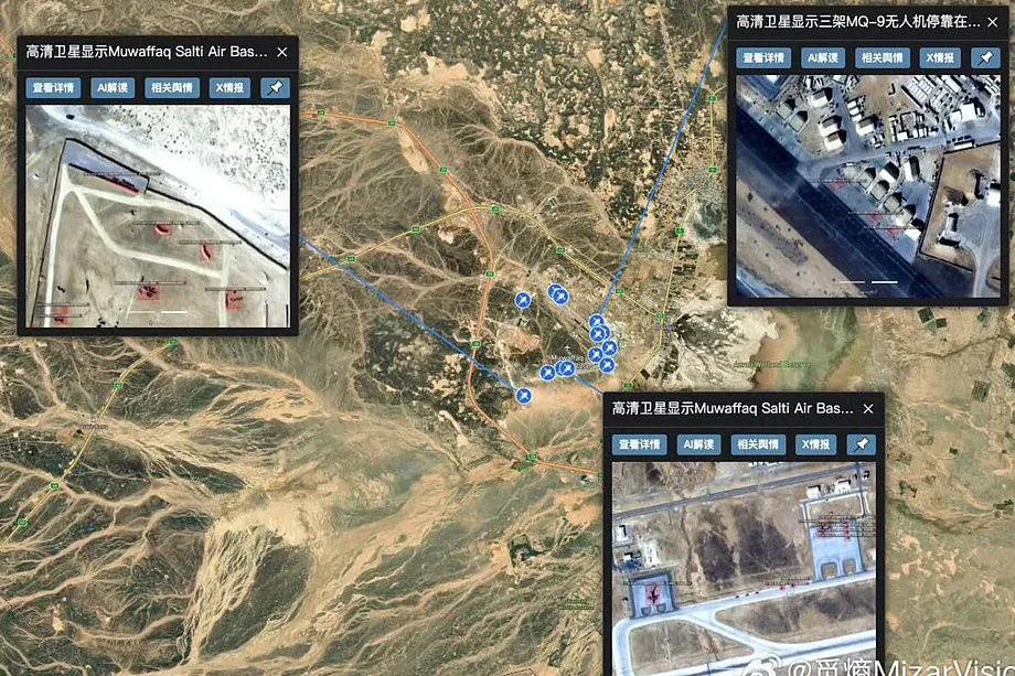
Since the beginning of the year, MizarVision had intensified a constant stream of captures that almost in real time depicted the expansion and reconfiguration of the US military presence in the region. In February, they shared images of US fighters at the Ovda airbase (Israel), the USS Gerald R. Ford aircraft carrier leaving the naval base in Souda Bay (Crete), an apparent withdrawal of US transport planes and helicopters at Al Udeid airbase (Qatar), and the deployment of THAAD missile batteries at the Jordanian base of Muwaffaq Salti. These were not just random spots on the tarmac: the company detailed models, counted fuselages, and pointed out daily variations in the arrangement of aircraft and defense systems.
The precision of the choreography was too accurate to go unnoticed. After the bombings and the subsequent Iranian response with ballistic missiles against US facilities in the region, several Western observers began to wonder if those images, presented as open-source intelligence, were serving a more subtle purpose: indirectly guiding Tehran.
As confirmed by this newspaper, MizarVision has ties to institutions associated with the People's Liberation Army (PLA) and its name is mentioned in technical publications and magazines linked to the Chinese military structure. In a context of systemic rivalry between Beijing and Washington, the boundary between a private company, a technological contractor, and an unofficial arm of the state deliberately becomes blurred.
In the past three years, the company has demonstrated analytical prowess in sensitive scenarios. In 2024, they shared images of the Chinese aircraft carrier Shandong sailing near the Philippines during escalating tensions in the South China Sea. A year earlier, they published captures of a US anti-submarine patrol aircraft Boeing P-8 Poseidon flying over the Taiwan Strait.
The qualitative leap lies not so much in the technology - as more commercial actors gain access to satellites - but in the narrative. In the weeks leading up to the offensive against Iran, MizarVision, which never discloses the source of the satellites, increased the frequency of publications focused on US assets in Saudi Arabia, Jordan, Greece, and Qatar, accompanied by detailed descriptions: exact number of F-22s, presence of tanker aircraft, rotation of strategic transports.
"The images show the US military continuously transporting supplies to Ovda using C-17s. During the same period, seven F-22s were stationed on the runway," the company wrote just 24 hours before Washington launched the operation dubbed Epic Fury.
In statements to the South China Morning Post, a spokesperson stated that the sources were "diverse," including Western and Chinese commercial entities, and described the firm as a specialist in geospatial analysis supported by artificial intelligence. Their website mentions automated vessel identification, change detection, and pattern recognition. The discourse aligns with the global rise of the sector: private constellations orbiting the Earth capturing millions of square kilometers daily and algorithms capable of turning pixels into military inventories.
However, the traditional support from the Xi Jinping government to Iran (especially economically through oil purchases) inevitably raises a question: To what extent has Beijing encouraged - or at least tolerated - a company with military connections to publish with such precision the location of US radars, launchers, or troop concentrations in the midst of escalating tensions with the Iranian regime?
Chinese analysts have claimed that the recent images in the Middle East used by MizarVision come from US satellites. But the added value lies not only in the capture, but in the analysis, aggregation, and timeliness of dissemination.
The company continues to publish high-resolution images of US military deployments these days. For Iran, subjected to a dense regime of sanctions and with limited intelligence capabilities against US technological power, this open mapping can be a valuable asset. For China, it could be a way to project influence and erode Washington's operational opacity.