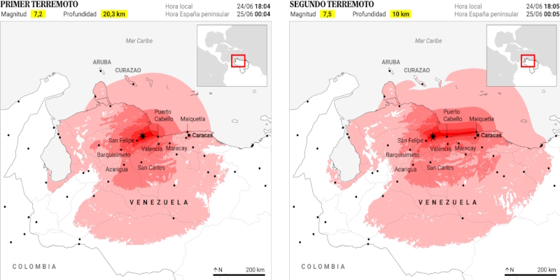
At 6:04 PM local time (midnight in the Iberian Peninsula) on Wednesday, June 24, a first earthquake of magnitude 7.2 shook northern Venezuela, with its epicenter in the cities of Yumare and Montalbán at a depth of 20.3 kilometers. Almost a minute later, a stronger earthquake, measuring 7.5, the most powerful to hit Venezuela since 1900, according to data from the United States Geological Survey (USGS), was recorded a few kilometers away. This second quake had its epicenter about 23 kilometers from San Felipe, the capital of Yaracuy state, at a depth of 10 kilometers.
The United States National Tsunami Warning Center noted that both earthquakes constituted a 'seismic doublet,' a rare phenomenon that occurs when two intense earthquakes happen with little time difference and in the same geographical area.
The explanation for this double earthquake lies beneath northern Venezuela, one of the most tectonically active areas in South America. The country sits on the boundary between the Caribbean Plate and the South American Plate, two huge rock blocks that move slowly in different directions. Unlike Chile, Peru, or Japan, where one plate subducts under another, many of Venezuela's earthquakes originate from strike-slip faults: fractures where plates slide horizontally past each other.
Over the years, the friction between the two blocks accumulates energy. When the rock's resistance is exceeded, that energy is released in the form of an earthquake. In exceptional cases, like the one on Wednesday, the initial rupture can destabilize a nearby fault and trigger a second major earthquake just seconds later.
Both earthquakes originated in an area where some of the country's main tectonic structures converge, including the Boconó Fault. The connection between this fault and the plates may have favored the release of accumulated energy in two consecutive episodes instead of just one.
The USGS report indicates that the city most affected by the first earthquake (magnitude 7.2) was San Felipe, home to around 221,000 people. The town experienced an MMI intensity level VIII, classified as severe, the highest shaking intensity observed during this seismic event.
Following San Felipe, the cities of Puerto Cabello and Tucacas experienced an intensity level VII (very strong). Approximately 209,000 and 14,000 inhabitants reside in these areas, respectively. Additionally, Valencia, one of the country's main urban centers, felt an intensity level VI (strong), as did Caracas. The Venezuelan capital, with over 2.2 million inhabitants, woke up on Thursday with significant material damage, including partial collapses and facade detachments. Furthermore, it was more severely affected by the second, stronger earthquake.
Overall, several million people felt the effects of the earthquakes. Of these, nearly a million were exposed to shaking classified as very strong or severe. The USGS estimates that the economic losses resulting from the first earthquake could range from 0% to 7% of Venezuela's gross domestic product.
Furthermore, the report highlights one of the factors explaining the disaster's high potential severity: the vulnerability of many buildings in the region. According to the agency, a significant portion of the population lives in unreinforced masonry or adobe structures, materials particularly sensitive to seismic movements. While there are also more resilient structures, the widespread presence of vulnerable buildings significantly increases the risk of casualties and damages.
The document also recalls significant seismic events in the area's history. Among them is the 6.6 magnitude earthquake that occurred on July 30, 1967, resulting in 240 fatalities and reaching a maximum intensity of VIII. The USGS also warns that other earthquakes in this region have generated secondary threats, such as tsunamis, which under certain circumstances can significantly worsen the impact of these events.
The second earthquake (magnitude 7.5) was more devastating than the first. According to USGS estimates, economic losses could range from 1% to 7% of Venezuela's GDP, with a 53% probability that damages will amount to between 10,000 and 100,000 billion dollars, compared to 36% from the first earthquake.
The coast bore the brunt of the devastation. Catia La Mar in La Guaira state experienced an intensity level VIII (severe) and became one of the main areas of destruction. Puerto Cabello in Carabobo and Ocumare de la Costa also reached this intensity level. The vulnerability of many structures helps explain the extent of the damages, especially in La Guaira, declared a "disaster zone" by the Venezuelan government.
The second earthquake also increased the shaking intensity in San Felipe and Caracas to level VII (very strong). In the capital, the intensity rose from level VI to VII compared to the first earthquake, significantly raising the risk of damages.
The comparison of both events shows how the first earthquake hit the country's interior harder, while the second, occurring just 38 seconds later, shifted the epicenter of destruction towards the coast and expanded its impact on densely populated areas like La Guaira and Caracas.
Currently, at least 188 people have died, and another 1,520 have been injured in Venezuela following the impact of these two powerful earthquakes, in addition to the thousands missing. The information is updated as of the close of Thursday, June 25.
Forecasts suggest that the toll could significantly increase in the coming days. The USGS estimates a 42% chance that the final death toll will range between 10,000 and 100,000 people and a 92% probability that deaths will exceed a thousand. These figures are not actual counts but estimates based on factors such as the earthquakes' magnitudes, the number of exposed inhabitants, and the vulnerability of structures in the affected areas. The official toll will be known as the days pass and the Venezuelan government obtains an accurate count.